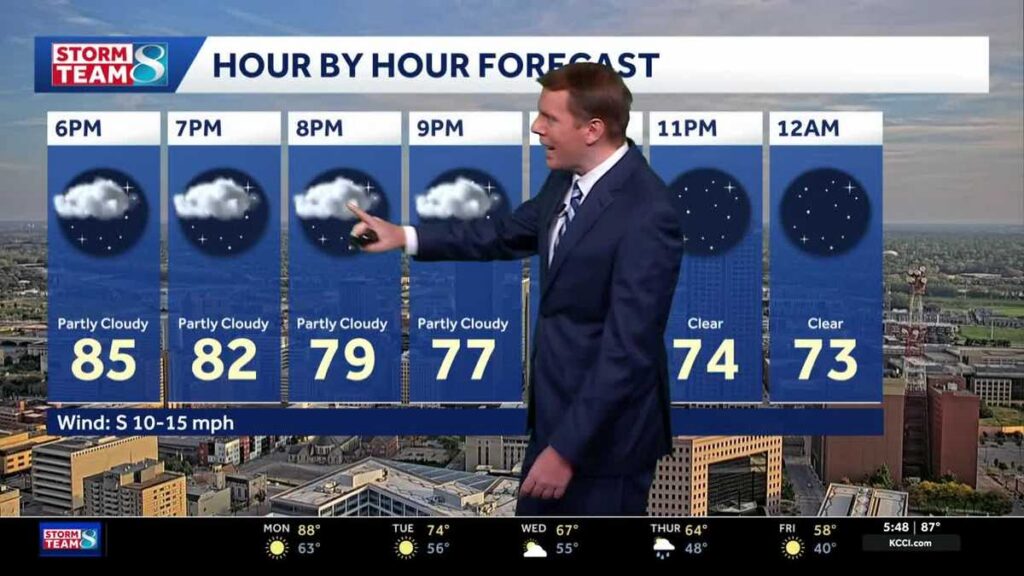
October in Iowa is delivering more summer than fall this year, with thermometers climbing into record territory across the state. Iowans should brace for one more day of intense heat before a dramatic cooldown reshapes the week ahead.
Central Iowa shattered high temperature records on Sunday, with Des Moines reaching 88 degrees — surpassing the previous record of 86 degrees set in 2024. Mason City matched that 88-degree mark, breaking a record that had stood since 1928, when the city last hit 85 degrees. Some locations climbed even higher, with Perry topping out at 91 degrees and Oskaloosa reaching 90. A steady south-to-southwest breeze helped push temperatures well above seasonal norms throughout the day. Forecasts for the region are tracked by KCCI meteorologist David Koeller.
Sunday evening will remain warm, with a persistent southwest wind of 10 to 15 mph keeping temperatures in the 70s well after sunset. Overnight lows are expected to settle only in the upper 60s to low 70s — far above what is typical for mid-October.
Monday Brings More Record Heat
Monday is shaping up to be another exceptionally warm day. Aside from a few morning clouds, expect abundant sunshine and high temperatures near 89 degrees in Des Moines. Southwest winds will increase, with gusts of 25 to 30 mph possible during the afternoon. The all-time record for October 13 in Des Moines stands at 91 degrees, set back in 1899 — meaning Monday’s forecast falls just short of that historic benchmark but remains well within striking distance. Iowans can monitor conditions in real time using interactive radar, weather alerts, and skycams covering more than 20 locations across the state.
A Cold Front Changes Everything Monday Night
The heat will not last. A cold front is expected to push through Iowa Monday night, triggering a notable shift in conditions by Tuesday. High temperatures Tuesday will drop to the mid-70s — still about 10 degrees above the historical average for this time of year, but a significant step down from the weekend’s extremes. A few showers or storms may develop Tuesday night across southern Iowa, though most of the state is expected to stay dry.
Wednesday’s forecast calls for cloudy skies that will keep highs in the mid-to-upper 60s. Rain chances will increase Wednesday night, with on-and-off showers expected to continue into Thursday. Thunderstorms are possible but no severe weather is anticipated. Highs Thursday will slip into the low-to-mid 60s as rain moves through the region. You can keep up with changing road conditions alongside the weather at KCCI’s traffic page.
Frost Possible by the Weekend
The end of the week brings the most dramatic change yet. After the rain clears Friday, blustery northwest winds will continue to pull cooler air into the state. Highs on Friday are expected to reach only the mid-50s. More significantly, Friday night into Saturday could bring the season’s first frost — or even a freeze — to parts of Iowa, with lows dropping into the 30s. Gardeners and farmers with sensitive crops should begin making preparations now.
For Iowans tracking the full forecast, the Des Moines outlook through the week is as follows: a low of 68 degrees tonight with south winds at 10 to 20 mph; a high near 89 degrees Monday with SSW winds at 15 to 25 mph; a low of 58 Monday night as winds shift from southwest to northwest; and a high near 74 degrees Tuesday under generally sunny skies.
Stay informed on the latest local developments in Iowa, including new businesses coming to Altoona’s shopping center, Iowa governor and Senate candidates clashing in first debates, and KCCI’s one-on-one interview with Dr. Oz. National news including Hurricane Isaias knocking out power for hundreds of thousands along the Gulf Coast is also being followed closely.