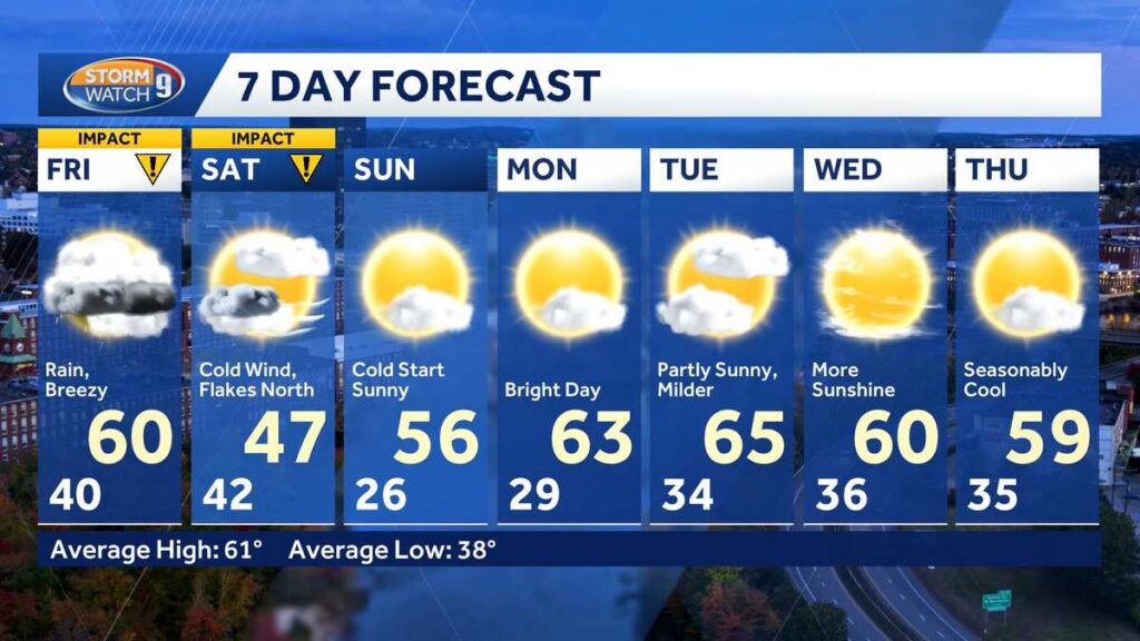
A significant weather shift is heading toward New Hampshire, bringing rain, plunging temperatures, and even the season’s first snow showers to parts of the state — all before the weekend is over. Residents should prepare for conditions that will feel more like November than mid-October over the next several days.
According to WMUR meteorologist Jacqueline Thomas, clouds will build overnight ahead of shower activity that is expected to develop by daybreak Friday. Overnight lows will hold mostly in the 40s before the rain arrives in earnest.
Friday: Rain, Then a Brief Warm-Up Before a Cold Front Hits
Friday’s weather will be defined by a round of steady rain, particularly through the morning hours. Showers are expected to become more scattered from mid-afternoon into early evening. Ahead of an approaching cold front, a warm front will temporarily push temperatures into the 50s and 60s for highs. A thunderstorm is possible late in the day as that cold front moves through — and it is that front that will trigger the dramatic drop in conditions heading into the weekend.
Saturday: Wind, Cold, and Snow for Northern New Hampshire
The most jarring part of this forecast arrives Saturday. Behind the cold front, gusty winds are expected to develop, with gusts reaching 30 to 40 mph at times. Afternoon temperatures will only climb into the 30s for northern areas and the 40s farther south — and with those winds factored in, it will feel significantly colder.
Snow showers are possible across higher elevations and the North Country on Saturday, marking one of the first notable chances for snowfall this season. Saturday may also be one of those unusual weather days where the official high temperature is recorded just after midnight, before temperatures fall sharply through the morning hours.
Residents can monitor current conditions and check the latest radar and traffic updates as the system moves through. For ongoing alerts and forecast updates, email alerts and the WMUR apps are available to keep residents informed.
Sunday and Beyond: A Return to Calmer Conditions
Relief arrives by Sunday, when high temperatures are expected to rebound into the 50s and winds will ease considerably. Dry conditions are forecast to continue through most of the following week, offering a more comfortable stretch of autumn weather after the weekend’s sharp chill.
The full forecast, including additional video coverage, is available through the WMUR weather forecast page. For questions or additional information, residents can reach out through the WMUR contact page or browse the full news team. All forecast content is produced in accordance with established editorial standards.